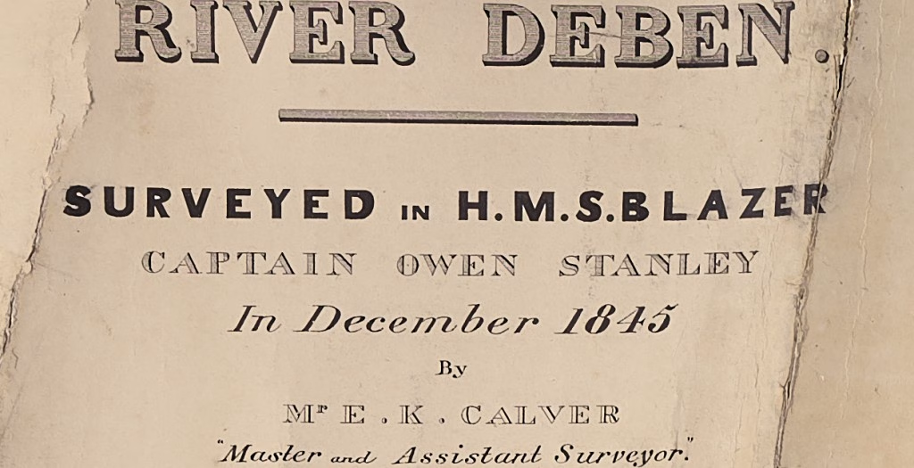
During the seventeenth to nineteenth centuries, the Royal Navy mapped the World and measured the Solar System. In 1845 H.M.S. Blazer, commanded by Captain Owen Stanley and assisted by her Master Edward Calver, made what must have been the first detailed survey of the river Deben under the supervision of Captain Washington .
Calver was the man mainly responsible for the work:
On this service he was employed in the Shearwater and Blazer- (his promotion to the rank of Master took place 28th January 1842), until October 1847. During that period “in addition to the offshore deep-water survey of the North Sea on which the ship was engaged,” Capt. Washington reported that “Mr. Calver took advantage of the times the vessel was coaling and refitting in harbour, to complete elaborate plans of Harwich and the rivers Orwell, Stour, and Deben, besides.
Memoirs – Dawson 1P116 – Dawson, Llewellyn Styles. Memoirs of Hydrography, 1885.
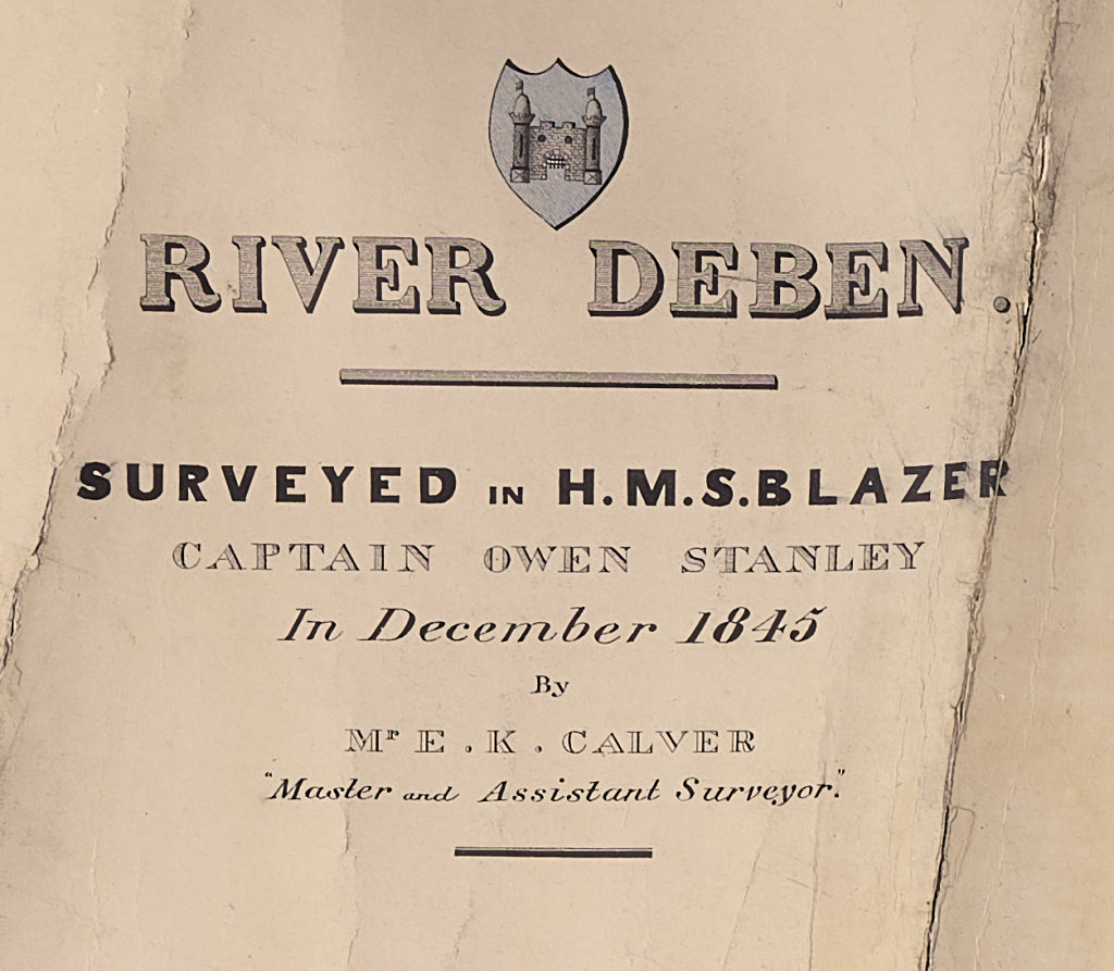
It was some time before the work appeared on a published chart as the Deben does not appear in the Admiralty list of charts 1864 but was included as a Woodbridge Haven plan in Chart 2052 by 189721898 Admiralty Catalogue . The Orwell and Stour charts had appeared by 18603Admiralty Catalogue of Charts, Plans, Views, and Sailing Directions 1860 : they would have been a higher priority.
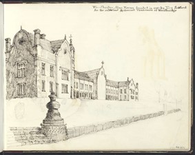
Whilst surveying the Deben, Stanley had some leisure time as he made a sketch and watercolour of H.M.S. Blazer at Woodbridge as well as the Seckford Alms Houses in January 1846. The Woodbridge artist and surveyor Isaac Johnson4Isaac Johnson- see here. died in the previous year so they would not have met, which is a great shame given their common interests. Sadly, he did not sketch at Waldringfield where the ship’s company must have spent some time in the Bush Inn (the Maybush) given the time of year and centrality of its location.
This is a Survey, not a Nautical Chart, there are no latitude or longitude markings, nor does it run North to South. There are un-numbered True Compass lines on Kirton and Bawdsey Churches but no indication of magnetic declination. The True Meridian direction, or True North, is shown near Martlesham.
A triangulation diagram centred on Waldringfield Church shows angles and distance in feet to other Churches. Distances for Ramsholt and Martlesham were found to be within 0.2% of modern measurements. The development of techniques using the Double Sextant and Station Pointer by Graeme Spence will undoubtedly have contributed to this. There are horizontal distance scales of one statute mile and thirty thousand feet. There are no land heights given. There are no contour lines5The use of the contour lines to which we are accustomed today was pioneered by Charles Hutton, a British mathematician whose ambitious 1774 survey set out to measure the mass of a mountain. It took nearly a century to adopt this excellent innovation. Hutton may have adopted the idea from that great sailor Sir Edmund Halley, who used a similar technique in the late seventeenth century when he mapped magnetic declination and made the first known use of isogonic lines. . This, and Colby’s 1837 map have contour shading for terrain rather than contour lines. This practice continued until Ordnance Survey maps of the later nineteenth century.
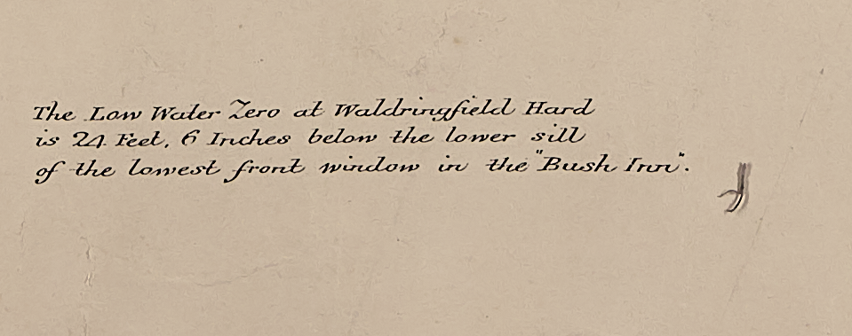
Depths are shown as spot soundings in feet, differing from modern practice by using a datum of Low Water Ordinary Spring Tides6subtract 0.4m to reduce to Chart Datum . For the drying areas, the figure given is the depth below High-Water Springs7deduct from 4.0m to reduce to drying height above Chart Datum . The Datum is established at several fixed points along the river including the Maybush but as Ordnance Datum Newlyn was not established until 19218An earlier Datum at Liverpool was established in 1844 but it was not used on this survey. it is unclear how these relate to modern heights.
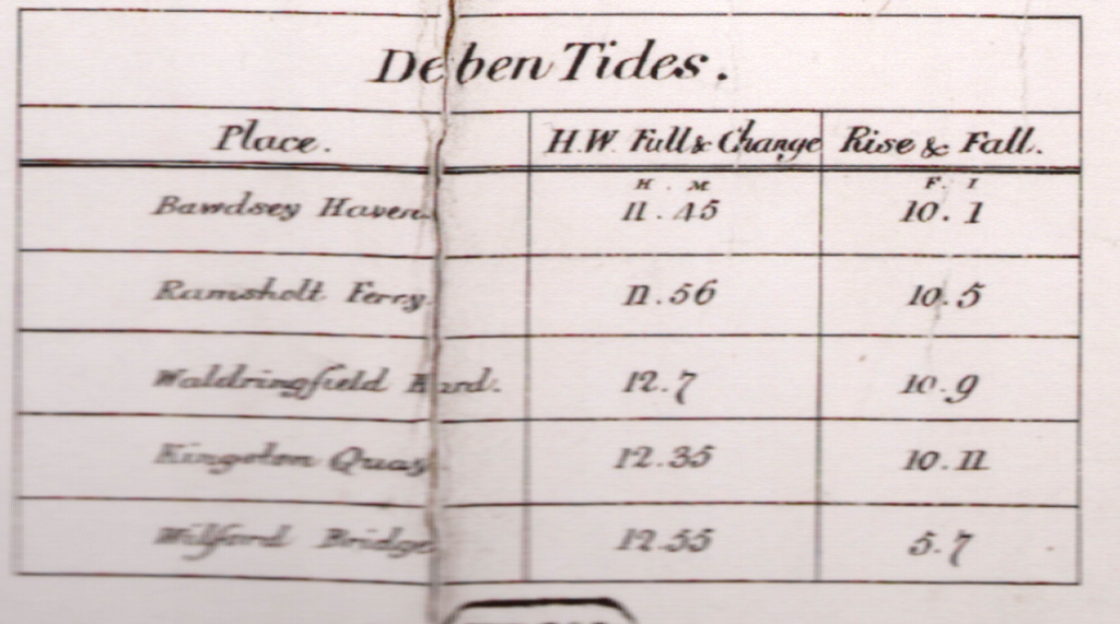
The tidal information panel shows the ‘Rise & Fall’ at the datum points. The largest range occurs at Kingston Quay with barely half of this at Wilford Bridge which explains some of the dinghy sailing issues on that stretch. Tide times are given as the hour of ‘High Water Full & Change’. This enables the navigator to calculate tidal heights from the phase of the Moon which would be published or could be derived from the date or date of Easter. The availability of Tide Tables was some time away.
Another panel provides the names of the navigational points, marks and reaches from the Haven to Wilford Bridge, many differ from modern usage and are, of course, more poetic. We seem to make little use of names on the river today.
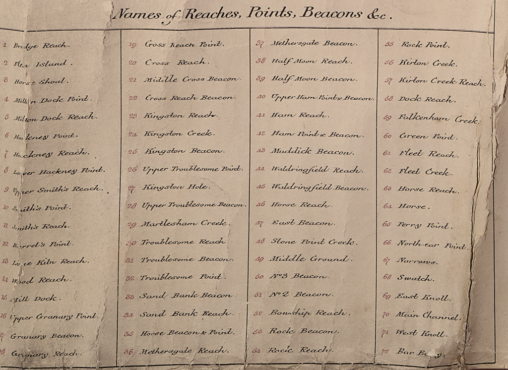
The survey has particularly good detail on the land around the river and is superior to the 1805 Ordnance Survey. An error made on the much smaller scale of 1783 Hodskinson’s map of Suffolk, and the 1805 Ordnance Survey is repeated, so they were consulted. The 1839 Tithe maps would also have been available. The only other likely source for the terrain detail found was the 1837 Thomas Colby Ordnance Survey which was available as a one-inch series by 1841: but this does not seem to have been used. The extract below shows the level of detail. The red numbers refer to the above list of names.
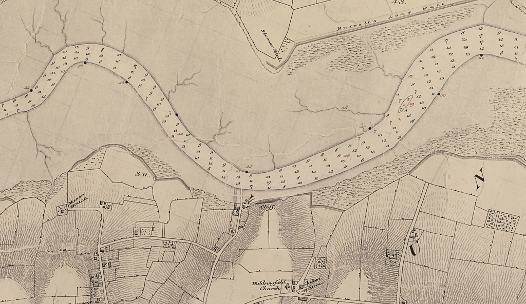
The next Ordnance Survey was not before 1861. However, the detail on this survey is better than earlier Ordnance Surveys, and the errors are different from, Colby’s map9Errors – Rivers Hall and Cross farm, for example.. The triangulation network and level of detail shown, suggest that they surveyed the vicinity of the river extensively and accurately.
A few points to note are:-
- Encroachment is in progress north of Methersgate on the east bank.
- Bush Inn, the lower sill of the front window taken as the datum for the Low Water Zero at the hard.
- Channels in the saltmarsh on the west side of Rocks Reach are well defined. Compared with a modern chart they seem to confirm that the mud digging for the cement works occurred in the following years.
- The Beacons…are of a very inferior description.’
- Burrell’s Point and Burrell’s Long Wall.
- Seamark for Sledway.
- The entrance at Bawdsey Haven looks difficult.
- Near Ear (Norther on Spence Chart) Point at Bawdsey with Life Boat Station.
- Roman Remains of Walton Castle.
- Martello (Mortella) Towers are shown with the exception of the elusive “S”.
- Mortella Place at Cobbold’s Point.
- Felixstowe Ledge is on the shore and buoys are maintained by the Lord of the Manor.
Footnotes
- 1P116 – Dawson, Llewellyn Styles. Memoirs of Hydrography, 1885.
- 2
- 3
- 4
- 5The use of the contour lines to which we are accustomed today was pioneered by Charles Hutton, a British mathematician whose ambitious 1774 survey set out to measure the mass of a mountain. It took nearly a century to adopt this excellent innovation. Hutton may have adopted the idea from that great sailor Sir Edmund Halley, who used a similar technique in the late seventeenth century when he mapped magnetic declination and made the first known use of isogonic lines.
- 6subtract 0.4m to reduce to Chart Datum
- 7deduct from 4.0m to reduce to drying height above Chart Datum
- 8An earlier Datum at Liverpool was established in 1844 but it was not used on this survey.
- 9Errors – Rivers Hall and Cross farm, for example.
Image Sources and Credits
Image Credits and Sources
- Deben-Plate: Source UKHO Archive. Copyright Protection has now lapsed
- Deben-Datum: Source UKHO Archive. Copyright Protection has now lapsed
- Tides-Deben: Bob C
- Deben-Reaches: Source UKHO Archive. Copyright Protection has now lapsed
- 1P116 – Dawson, Llewellyn Styles. Memoirs of Hydrography, 1885.
- 2
- 3
- 4
- 5The use of the contour lines to which we are accustomed today was pioneered by Charles Hutton, a British mathematician whose ambitious 1774 survey set out to measure the mass of a mountain. It took nearly a century to adopt this excellent innovation. Hutton may have adopted the idea from that great sailor Sir Edmund Halley, who used a similar technique in the late seventeenth century when he mapped magnetic declination and made the first known use of isogonic lines.
- 6subtract 0.4m to reduce to Chart Datum
- 7deduct from 4.0m to reduce to drying height above Chart Datum
- 8An earlier Datum at Liverpool was established in 1844 but it was not used on this survey.
- 9Errors – Rivers Hall and Cross farm, for example.
Image Credits and Sources
- Deben-Plate: Source UKHO Archive. Copyright Protection has now lapsed
- Deben-Datum: Source UKHO Archive. Copyright Protection has now lapsed
- Tides-Deben: Bob C
- Deben-Reaches: Source UKHO Archive. Copyright Protection has now lapsed
