We use knots as a measure of speed on the water. How does this work, and how did it come about? The history of the “knot” 1Knots are also used in aviation but mixed with other units over the years. is intimately tied to the method used for measuring it and this presents a variety of conflicting and confusing sizes and units. Conversions to metric units are given where appropriate but the knot evolved within older systems.
As navigation on the sea improved, sailors, using Celestial Navigation, became more certain of their latitude North or South. Progress East or West, however, could not be measured in this way before the “Longitude Problem” was solved in the 18C. Without reference to land or stars, they measured the movement of the vessel through the water. This enabled a “Longitude by account” to be added to the Latitude obtained from the Sun and Stars giving a position.
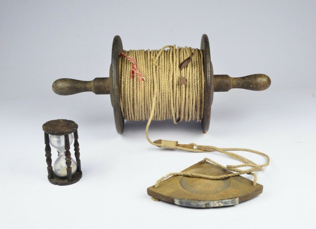
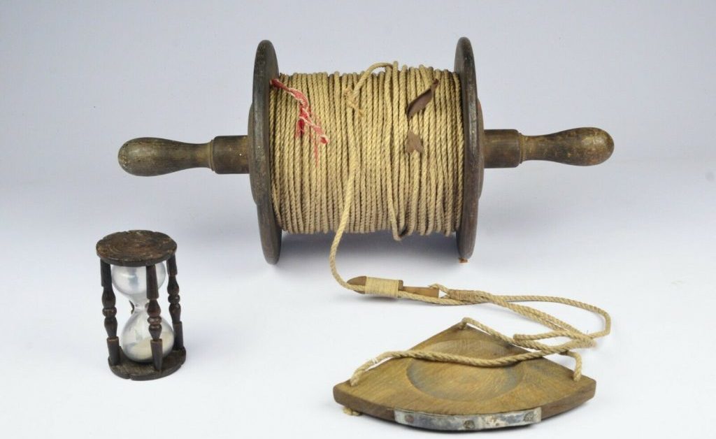
One method of speed estimation was the “Dutch Log” where an object was cast overboard at the bow and its travel along the hull to the stern was timed. This was inaccurate so, from the late sixteenth century 2The Smithsonian Museum suggest 1575 3See page 126 of 1809 Bowditch a “log”, more properly a piece of wood, or “chip”, on the end of a line with knots a fixed distance apart was trailed for a pre-determined time. The knots were counted as they passed through the hand of the sailor. The term was used from, at least, 1633 to express speed and by 1748 was associated with the Nautical Mile. 4Shorter Oxford English Dictionary The distances between knots included 47′ 3″,48′, 50′, 51′ (around 14.5m to 15m): the times used included 14 seconds, 15 seconds, 28 seconds and 30 seconds. These choices invite deeper investigation.
Speed is equivalent to time divided into the distance travelled. The hour was, in earlier times, measured by a calibrated sand glass and later by a chronometer. The Nautical Mile was, historically, less well defined. However, the degree 5The circumference of our planet has 360 degrees, and each degree is subdivided into sixty minutes. of Latitude was well understood and could be measured, with varying accuracy, by instruments such as Astrolabes and later sextants. Thus, after a dalliance with Leagues as a measure and confusion with “Sea Miles”, the Nautical Mile came to be equated to one (arc)minute, or sixtieth of a degree. The degree and its subdivision, the (arc)minute needed to be converted to a distance. 6Edmund Gunter, a British Mathematician, suggested in 1623 using 20 Leagues, or 60 miles, for each degree. He was of much greater importance in developing the Quadrant and Scale. Therefore, given the equivalent distance as above a degree or minute became a useful measure.
The measurement of the Earth has become more precise over the centuries and the accepted dimensions have, therefore, varied. The irregular shape of the Earth means that there is no single, correct answer and different countries had their own views as to the correct figure. A remarkably accurate figure has been available since ancient times with Eratosthenes calculating a value within about 2%. 7See Eratosthenes measures the Earth In 1615 Willibrord Snellius (Snell’s Law) re-calculated the degree, albeit in Flemish Rods and German Miles. 8See Dutch Maritime Museum . The U.S. and U.K. agreed to set the value as 6080′ (1853m) in 1886 based on one minute of Latitude. However, the Admiralty continued using different values, such as 6075′ 6076′, until the 20C. The IHO definition of the Nautical Mile is now 1852m exactly. 9The Units of Measurement Regulations 1995 states 1853m A knot 10The unit is written in various ways but the IHO definition is “kn” , abbreviated as kn, is defined as one Nautical Mile (M) in one hour. 11Converts to 1.852kph, 0.514m/s or 1.15mph

From ancient times until the late 19C sailors used a lead line to measure, or sound, the depth of water. This was calibrated in fathoms, where a fathom is 6′ (1.8m). It seems reasonable that the lead line, used for sounding depth, might, at first, have been used as a log. This was probably a British innovation in the sixteenth century. 12 See Dutch Maritime Museum
In one minute about 101′ (6080’/60= 101.67’=about 17 fathoms) or 17 fathoms of the line would run out at a rate of one knot. Halving this to 30 seconds then a 150-fathom line would suffice up to ten knots, but greater speeds would require a longer line or less time.
The log line chip was heaved from the leeward stern quarter, holding onto the reel of course. 13See Sailing Techniques: Heaving the Lead and Heaving the Log and Age of Sail A length of “stray” line, about 10 to 15 fathoms, was allowed to get the log past the disturbed wake of the ship before the measurement began. Once the white rag which terminated the stray was reached “turn” was called by the linesman. The sand glass, often attached to the taffrail on the transom, was turned. When the glass emptied “stop” was called by the glass watcher the knotted line was nipped. The number of knots passed would be recorded as well as the number of intermediate marks from the last fathom. Initially, these would have been fathoms corresponding to an eighth of a knot although in some ships the space between knots was sub-divided into tenths. So the speed would be called out as, say, “Four knots and five fathoms”, meaning 4⅝ knots. If the ship was becalmed then the call would be “No knots, no fathoms”. At the end of the reading, a smaller line was pulled to release a plug which allowed the log to be retrieved without resistance. It may be that this had to be done quickly to avoid the reel being dragged into the sea.
‘Six and a half knots, if you please, sir. – Seven knots two fathoms. – Almost eight knots. – Eight knots and three fathoms. – Nine knots. – Ten knots! Oh sir, she’s doing ten knots!’
Patrick O’Brian – The Reverse of the Medal, ch.3, paragraph 114 14Patrick O’Brian – The Reverse of the Medal, ch.3, paragraph 114
The wind had diminished by now and the Surprise logged no astonishing number of knots, but there was that ineffaceable memory, dear to all the people, of a whole 150 fathoms being run straight off the reel before the glass was out; and in any case she was still bringing the land a mile closer every four or five minutes.
Patrick O’Brian – The Far Side of the World, ch.9, paragraph 147. 15Patrick O’Brian – The Far Side of the World, ch.9, paragraph 147
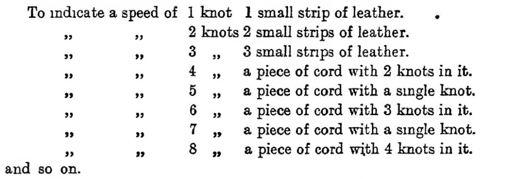
Now, the use of a line with knots at 8 fathoms and a sand glass of 30 seconds gives a measure of 5760 feet (8x6x60x2) which is around 5% less than a Nautical Mile. A prudent captain would not want to underestimate distance as it might place the ship in danger, so this seems a sensible system. However, to improve accuracy, there were two options: increase the distance between knots: reduce the time measured. There were variations of the distance which settled on 47’3″. This was divided into eighths or tenths, possibly according to the captain’s taste. This only gives a distance of 5670′ so was combined with a special purpose sand glass of 28 seconds. Was the 28-second sand glass a marketing exercise by instrument makers? This arrangement (47.25x60x60/28) gives a distance of 6075′ which is very close to a Nautical Mile. Why this pairing came about is unclear. A simple calculation (6080/120) shows that a knot distance of 50’8″ and a 30-second sand glass gives almost the correct relationship. 16See:1799 Moore-Bowditch from page 144 discusses the options for line length and glass time. :1809 Bowditch from page 125 suggests ten fathoms of five feet and a thirty second glass. :1883 Manual of seamanship for boys see page 314 for the process. :1881 Reeds Seamanship describes different glass times and line lengths (47′ 3″1/2, 50′): 1948 Nicholl’s Seamanship page 135 gives details of marking on the line and suggests a knot distance of 23′ 7″.

A refinement was to halve the distance between knots to double the speed range of a given length of line or to halve the time of the sand glass to 14 seconds. This reduced accuracy significantly. In the 19C mechanical or patent, logs appeared which were more accurate, convenient and gave a continuous reading rather than only every hour or two. Various corrections were suggested for different conditions, such as a following sea. 171817 Nories Epitome page 63
The knot (and Nautical Mile) has been refined over the last few centuries only settling in the late 20C. Possibly by coincidence, it became defined by the degree but is now defined by the metre. The log line evolved rather than being invented and there was a good deal of variation in the lengths of line used. 18A study of the different variations would be interesting. This was probably the preference of the captain. The sand glasses became standardised to 30, 28 and 14 seconds as these had to be manufactured and calibrated. In all, the instrument had a life of around 250 years.
Notes and references.
- 1Knots are also used in aviation but mixed with other units over the years.
- 2The Smithsonian Museum suggest 1575
- 3See page 126 of 1809 Bowditch
- 4Shorter Oxford English Dictionary
- 5The circumference of our planet has 360 degrees, and each degree is subdivided into sixty minutes.
- 6Edmund Gunter, a British Mathematician, suggested in 1623 using 20 Leagues, or 60 miles, for each degree. He was of much greater importance in developing the Quadrant and Scale.
- 7
- 8
- 9The Units of Measurement Regulations 1995 states 1853m
- 10The unit is written in various ways but the IHO definition is “kn”
- 11Converts to 1.852kph, 0.514m/s or 1.15mph
- 12
- 13
- 14Patrick O’Brian – The Reverse of the Medal, ch.3, paragraph 114
- 15Patrick O’Brian – The Far Side of the World, ch.9, paragraph 147
- 16See:1799 Moore-Bowditch from page 144 discusses the options for line length and glass time. :1809 Bowditch from page 125 suggests ten fathoms of five feet and a thirty second glass. :1883 Manual of seamanship for boys see page 314 for the process. :1881 Reeds Seamanship describes different glass times and line lengths (47′ 3″1/2, 50′): 1948 Nicholl’s Seamanship page 135 gives details of marking on the line and suggests a knot distance of 23′ 7″.
- 171817 Nories Epitome page 63
- 18A study of the different variations would be interesting.
Image Credits and Sources
- Log and Line: ebay
- Markings from Nicholl’s Seamanship 1948: Nicholl's Seamanship 1948
