These notes cover from the Blackwater to the Ore in chronological order.
A fifteenth-century pilot guide describes the ‘Waynes and Weirs at Orwell (Harwich) Haven’, the entrance was quite different with many fishing weirs such as Andrews and Platters. These most likely necessitated the services of a pilot to be safely navigated.
The Spitway may have been marked in the fourteenth century as a pilot refers to ‘the merkis of the spetis’, or ‘marks of the spits’ although this could have referred to the bearing on St Osyth Priory. There was a buoy marked on a 1675 Thames Estuary Chart, the 1596 Chart is less clear but it seems likely there was a buoy there.
The Gunfleet had a buoy in 1628, supposedly the first in Essex.
Roughs Shoals was buoyed in 1776.
The 1790 Stanier Thames Estuary chart only shows buoys on the Buxey, Spitway, Gunfleet and Roughs.
Woodbridge Haven had a single buoy in 18041See 1804 Spence Chart, the 1845 River Deben survey, describing the river, states ‘The Beacons…are of a very inferior description.’ Deben Reaches and Marks gives more detail.
Orwell Haven had no buoys in 1804 relying upon (often mis-) leading marks, a constant source of problems. By 1852 there were several buoys with familiar names leading into the Haven: the Beach End buoy needed annual re-positioning due to the growth of Landguard Point.
The Stone Bank buoy dates to 1821 and must have been to assist the mining of Cement Stone, an important industry then. A. C. Stock, in Sailing Just for Fun, when passing in the 1980s, describes the buoy as “‘Pickwickian’ in its red and white chequered waistcoat”.
From a report of the River Orwell in 1860, ‘We have no lights of beacons, the channel being merely partially buoyed with cask buoys’2Great Britain Commission Appointed to Inquire into the Condition of Lights Beacons Buoys and, Report of the Commissioners Appointed to Inquire Into the Condition and Management of Lights, Buoys and Beacons: Together with a Letter from Rear-Admiral W.A.B. Hamilton, Chairman of the Commission, and Appendix and Index (H.M. Stationery Office, 1861). These were placed in 1840 and changed to iron buoys in the 1860s3‘Orwell Estuary. The Story of Ipswich River (With Harwich and the Stour). by Arnott, W G – 1954’. with lighting only appearing in the 1930s.
By 1886, Aldbro’ Ridge to SE Maplin and the rest of the Thames Estuary and Irish Coast conformed to British Uniform Buoyage4‘The History of Harwich Harbour, … H C Hughes’..
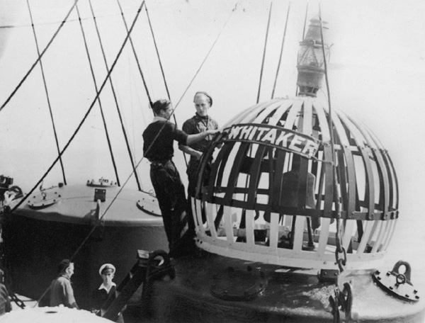
Eagle was in place by 1890, N.Eagle by 1903. In 1907 Whitaker and Knoll were two of the three gas-lit buoys in the area. The Colne was buoyed with small black casks and small red cones in the early twentieth century5, see ‘London to Lowestoft A Cruising Guide to the East Coast’.

National Maritime Museum Greenwich-No restrictions via Wikimedia Commons
Walton Backwaters was not buoyed in Messum’s 1903 account6S.V.S.C Messum, East Coast Rivers, 1903rd ed., n.d.. However by 1926 from Pye End to Stone Point, the buoys were similar to the modern locations.7WFYC Chart.
For the Stour, in 1903 Messum describes a series of spar buoys westwards of Wrabness although no buoys are shown on the 1943 or 1970 chart west of Parkestone Quay.
On the 1907 Chart, Orwell Haven has a gas-lit Bell buoy roughly where Landguard is now.
Orford Haven had leading marks only as late as 1927, it was recognised as a difficult entrance generally needing the help of the pilot. When the channel was buoyed is not yet known.
Medusa dates only from the 1930s and was probably positioned for traffic to the Explosives Works in Oakley Creek.
By 1948 Harwich had black cones to starboard, and red cans port but the River Orwell had red cones to starboard and black cans to port. This was a time of transition and perhaps the port authorities were just out of step.
The 1948 Orwell Haven buoys were similar to today but without the Deep Water Channel, most were gas-lit. Many shoal areas have been lost in the Haven by dredging, such as Altar, Gristle, Cod and Bone. These will be described in due course.
Footnotes
- 1See 1804 Spence Chart
- 2Great Britain Commission Appointed to Inquire into the Condition of Lights Beacons Buoys and, Report of the Commissioners Appointed to Inquire Into the Condition and Management of Lights, Buoys and Beacons: Together with a Letter from Rear-Admiral W.A.B. Hamilton, Chairman of the Commission, and Appendix and Index (H.M. Stationery Office, 1861).
- 3‘Orwell Estuary. The Story of Ipswich River (With Harwich and the Stour). by Arnott, W G – 1954’.
- 4‘The History of Harwich Harbour, … H C Hughes’.
- 5, see ‘London to Lowestoft A Cruising Guide to the East Coast’
- 6S.V.S.C Messum, East Coast Rivers, 1903rd ed., n.d.
- 7WFYC Chart
