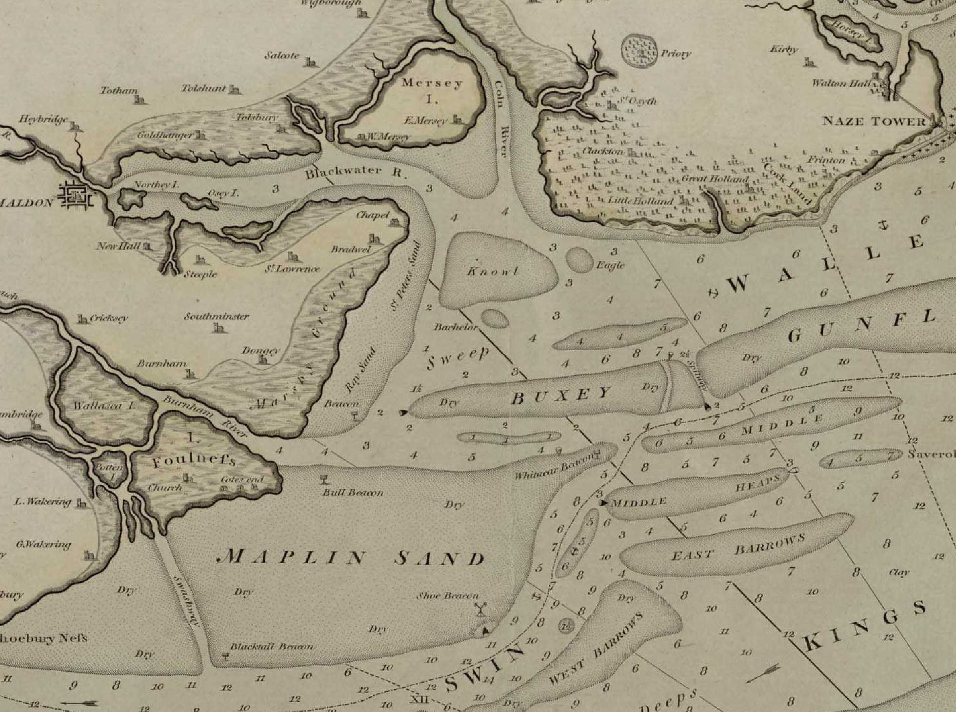
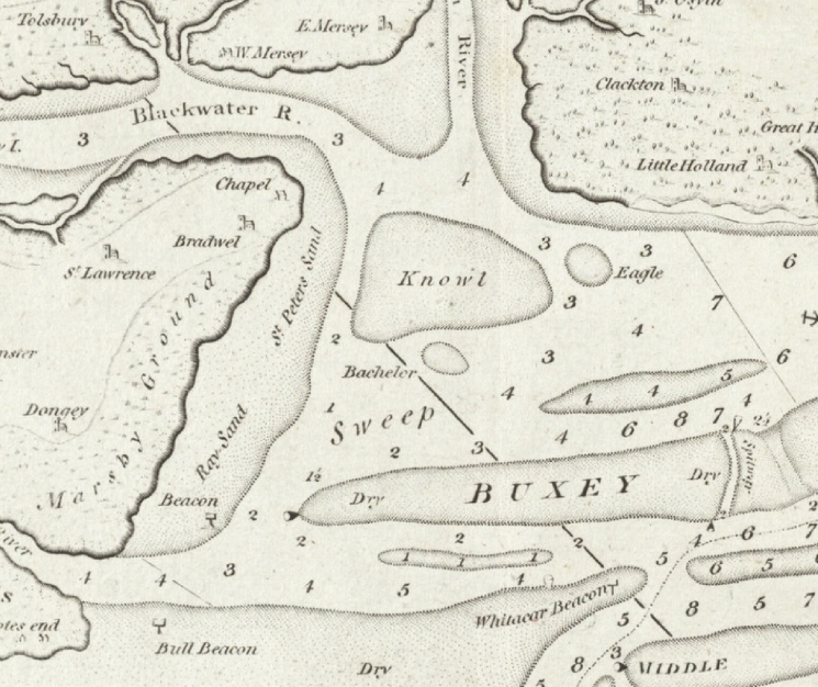
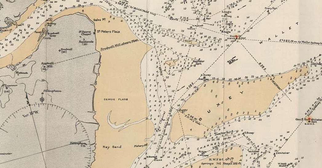
Today, the Ray Sand Channel dries at about 0.6m or 2′ but it was not always so: it has changed depth from 13′ CD to 2′, a reduction of 4.5m over only 75 years: the channel now dries. The channel has little use today, other than a shoal draught shortcut between the Blackwater and Crouch. At some point, the marshes to the west were enclosed by sea walls and this probably contributed to the shoaling to the east although the main cause is the shifting configuration of the sands. The channel runs through, or over, the intersection of Ray Sand, St Peter’s Flat, Knowl and the Buxey.
The 1797 William Heather Chart shows an inshore route from the Swin via Havengore, Crouch, past the Ray Sand and into the Wallet.

John Norden’s Map of Essex, 1594, shows the general area but is inconclusive. 1672 Seller’s Atlas maritimus shows the Ray Sand and St Peter’s Sand but no channel. The channel is shown on charts as early as 1770. The origin of the name is not known. The 1782 John Chandler Chart shows 2 fathoms LWOS and similar marks to the 1801 William Heather Chart which has a clear channel marked by a beacon and a buoy with 1- 2 fathoms.

Not much had changed by 1890, according to Tizard:
…;the channel between the Buxey sand and Dengie flat has about 12 feet, and is merely an outlet for the River Crouch. It will therefore be seen that the Wallet is really only a channel to the Rivers Colne, Blackwater, and Crouch, and is of no importance as a channel towards the Thames. It was last surveyed by Staff-Captain Parsons in 1877, and as its features have not materially changed since 1800, it will probably not be surveyed again for many years, unless the swatchways across the Gunfleet should deepen or others open up of sufficient importance to render the Wallet useful as a traffic channel. There were formerly other swatchways across the Gunfleet, but these are now closed.
Tizard, T. H. (Thomas Henry). The Thames Estuary. 1890, .
By 1903 Lieut. Messum1Messum, S. V. S. C. East Coast Rivers. 1903 describes the channel and provides a chart with a least depth of 9′ LWOS. Messum is primarily concerned with the shortcut across Batchelor Spit. The Buxey Beacon was then a “T” shape and was still there in 1925.

However, by 1925 the channel had shoaled to around 2′ 9″ below LWOS21925 Irving, Lt Cdr John. Rivers and Creeks of the Thames Estuary. . Alker Tripp, sailing in the 1930s- 1940s does not mention depth but does say that the sides are so steep that the lead is of no use31930s-1940s Tripp, High Alker. Shoalwater and Fairway by H. Alker Trip.. Over the early twentieth century the channel has shoaled and according to the 1965 East Coast Rivers pilot book the channel had reached a drying height of 2′, much like today (2023).
The ebb tide in the channel would have kept it clear but there must have been some change that diminished this, after which the channel fairly rapidly silted up.
Consulting H.Muir Evans for the origin of the name reveals some other Rays:
If we turn to Canvey Island, in which the placenames are very similar to those on the Dengie Marsh, we notice Hadleigh Ray and Ray Gut Channels inside the island, and if we study a modern ordnance map we find in Dengie Marsh, Ray Wick lying to the east of Southminster. According to Isaac Taylor “the root Rhe or Rhin is connected with the Gaelic ‘rea’ rapid.” Hence, we have river names such as Rye in Kildare, Yorkshire and Ayrshire, the Rey in Wilts, the Ray in Oxfordshire and Lancashire and many other variations. If Ray in this locality is derived from this root it would mean a stream or run. Separating Mersea Island from the mainland is the Strood Channel which joins the “Ray.” It is interesting here to note that the Strood Channel is continued by the Pye Fleet, on the north side of which is Pewit Island.
So that we have the same placenames here as we have encountered in the Walton backwaters. It seems on the evidence that Ray denotes a stream, and that the meaning of the word has been lost in the term “Ray Gut”; it is suggestive also that the north part of Ray Sand is intersected by a run which joins the site of the old Spits Land Deep and is fed by dykes starting from Ray Wick.
Muir Evans, Harold. ‘SANDS, GATS and SWATCHWAYS between HARWICH and the NORE’. Mariners Mirror, 1930.
Before the sixteenth century, the coastline may well have been different, this is covered in The Essex Coastline in the Middle Ages.
Sources
Also see H.Muir Evans and chart p26. – Muir Evans, Harold. A Short History of the Thames Estuary. Imray, Laurie, Norie, Wilson, which shows the beacon.
Footnotes
- 1Messum, S. V. S. C. East Coast Rivers. 1903
- 21925 Irving, Lt Cdr John. Rivers and Creeks of the Thames Estuary.
- 31930s-1940s Tripp, High Alker. Shoalwater and Fairway by H. Alker Trip.
Image Sources and Credits
Image Credits and Sources
- 1801-William-Heather-Chart-Extract-for-Ray-Sand: 1801 William Heather Chart - wikimedia
- 1902-Chart-of-Ray-Sand-from-Messums-East-Coast-Rivers: 1902 Chart of Ray Sand from Messums East Coast Rivers
- 1Messum, S. V. S. C. East Coast Rivers. 1903
- 21925 Irving, Lt Cdr John. Rivers and Creeks of the Thames Estuary.
- 31930s-1940s Tripp, High Alker. Shoalwater and Fairway by H. Alker Trip.
Image Credits and Sources
- 1801-William-Heather-Chart-Extract-for-Ray-Sand: 1801 William Heather Chart - wikimedia
- 1902-Chart-of-Ray-Sand-from-Messums-East-Coast-Rivers: 1902 Chart of Ray Sand from Messums East Coast Rivers