
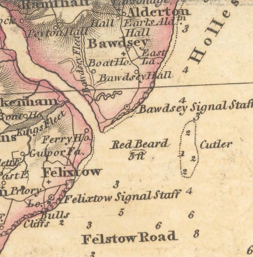
Nowadays we are familiar with Cutler Sand as a 2m shoal about one and a half miles off Bawdsey Cliff, but few have heard of Redbeard.

There was a Cutler or Curtiller ship-owning family in the Bawdsey area from the twelfth century, so this is probably the origin of the name of the Cutler Sand. The sand is charted from the mid-seventeenth century, albeit with some height changes. It is not featured on a mid sixteenth-century chart although it must have existed. A late seventeenth-century chart shows Cutler as an onshore bank and the contemporary Coasting Pilot clearly describes it:
Cutler is a small Sand that lyeth right off from Balsey-Cliff about a short mile, and hath but six foot water on it at low-water, and two Fathom between it and the Cliff. The Mark to go clear of of it, is to keep Harwich Steeple just open of Felsto-Cliff.
1693 Greenvile Collins,The Coasting Pilot
Arnott tells us that ‘Redberde banke’ was recorded around 1540 and associated with the Redberd family of Bawdsey. He also suggests that the bank was the remnants of the shingle spit from a time when the land extended further East. This seems reasonable and agrees with seventeenth and eighteenth-century charts, which show a shoal just off the mouth of the Deben at 5′ depth (equivalent to 2m CD). It had disappeared by erosion or absorption into the entrance shingle by the early nineteenth century.
showing Cutler onshore and a supposed Redbeard at Deben mouth – No offshore Cutler.
Redbeard’s Remains or Something New?
Reliable charts from the early nineteenth century demonstrate that Redbeard had gone by then. But, is it returning?
Interest in this topic resulted from a suggestion that a feature found on modern bathymetry might be the remnants of Redbeard1Talk at Waldringfield by Prof. Helene Burningham December 2024. Whilst it cannot be the same feature it may be similar.
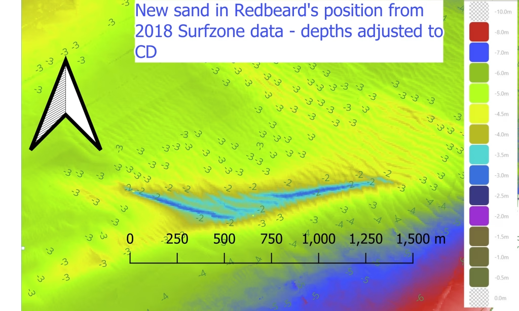
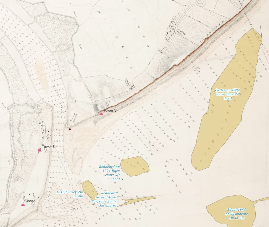
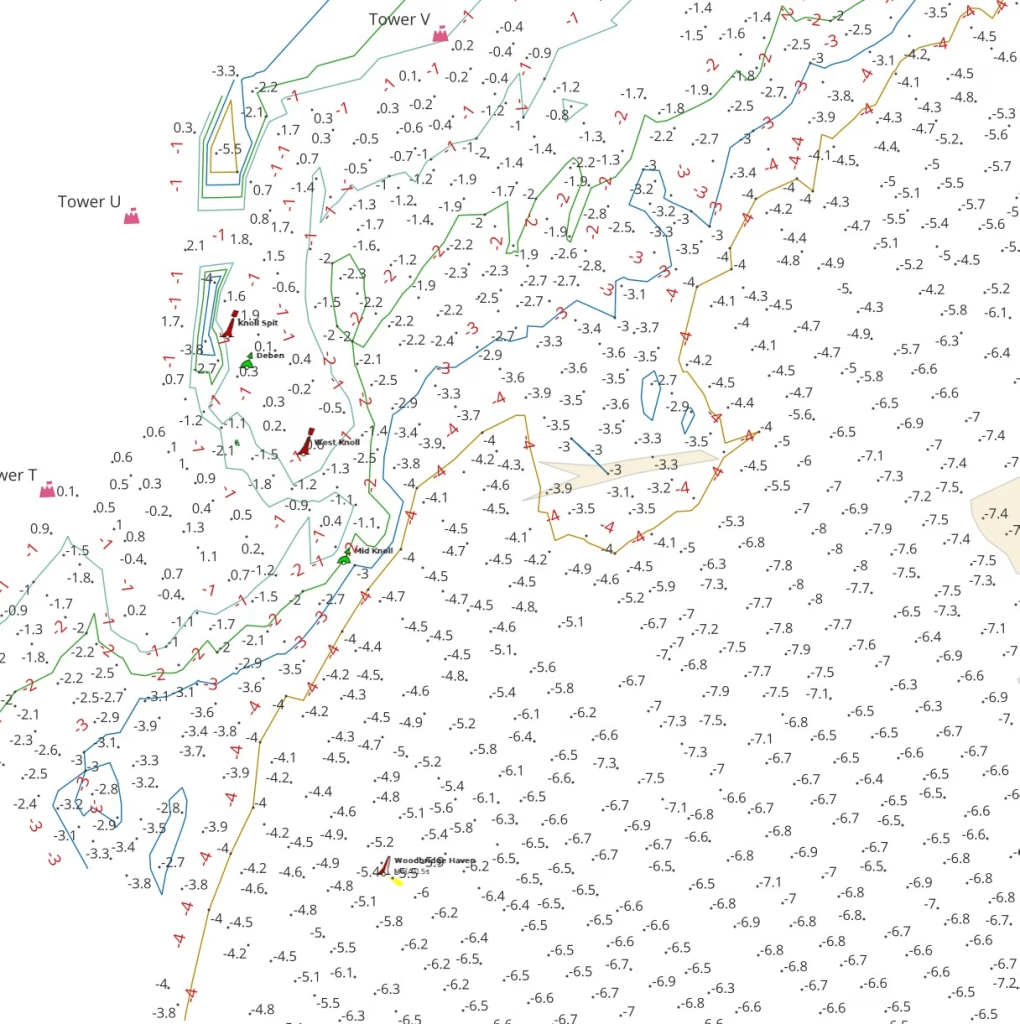
Surfzone bathymetry from 2018 reveals a feature of similar depth in the estimated position of Redbeard. It is about 500m West to East and 100m North to South at about 2m CD and 500m due East of Martello T. The movement of the 2024 buoy positions demonstrates the volatility of the banks in this area.
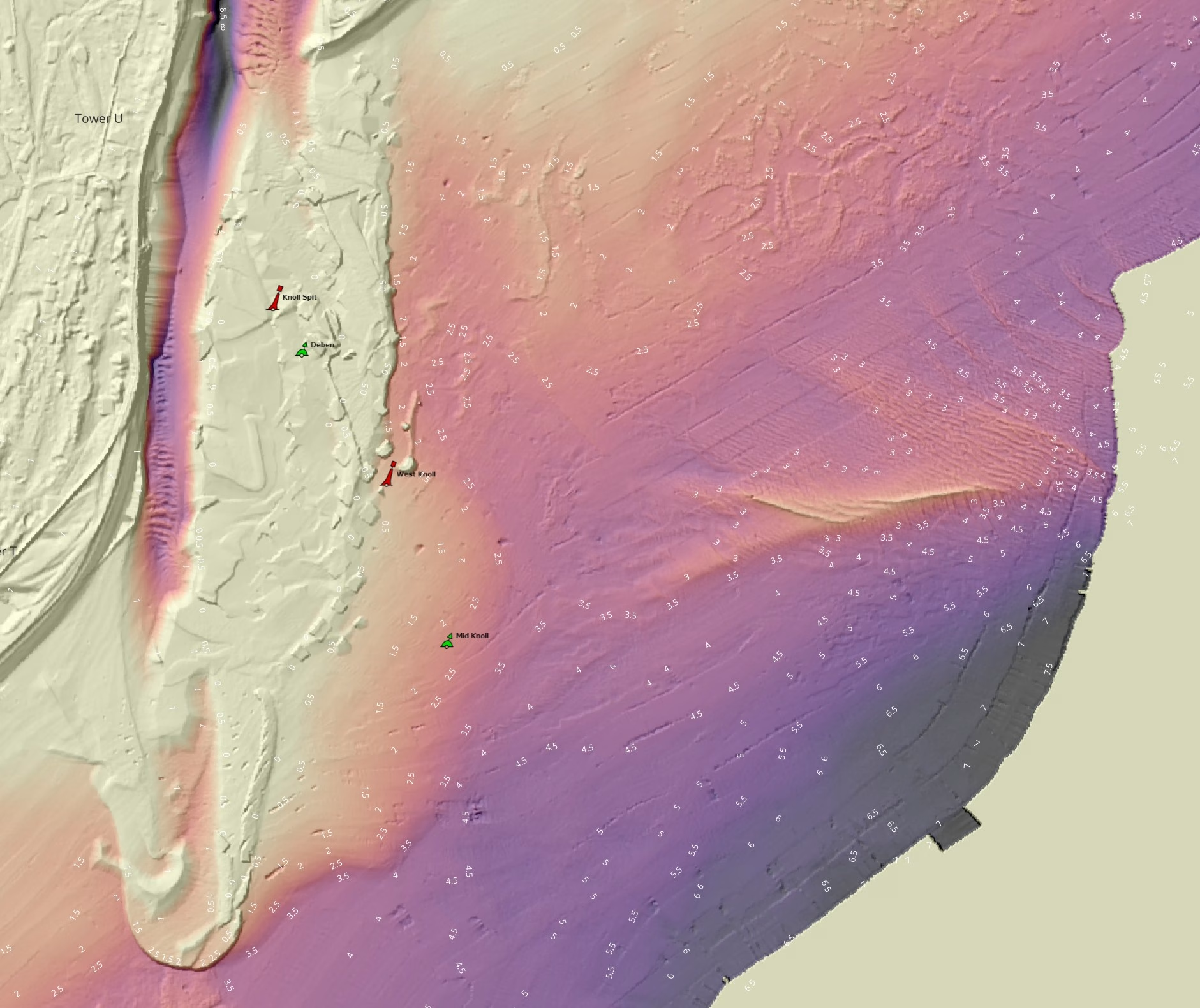
The feature does not appear significant in 1984 bathymetry but is depicted as an obstruction on local charts from the early 2000s22008 East Coast Rivers and the annual Deben chartlets. and now seems to be growing. Perhaps it deserves a name, it will be interesting to track its development.
Bathymetry data32018 0.5m resolution of Cutler Sand. also revealed details of the nearby wreck of HMS Arethusa by the Cutler Sand.
Review of Charts
The following discussion reviews the charts and bathymetry relating to these features in detail. It should be borne in mind that from a navigational perspective, the waters inshore of Cutler were of little significance. Whilst Bawdsey Haven was once important, this diminished greatly from the fourteenth century.
Sixteenth to Nineteenth Century Charts
The earliest charts seen are from the mid-sixteenth century which show a bank offshore of the Deben entrance, either Cutler or Redbeard4 would be useful to check the 1584 A chart of the east coast of England – Richard Poulter, not sure if this is the same as 1585 Harwich to Yarmouth which shows the bank but is not readable on my copy – needs a BL visit. A Henry VIII chart of the Deben entrance does not mention Cutler but does describe ‘Redberde Bank against Bawdsy Cliff’5See W.G.Arnott, W G. Suffolk Estuary : The Story of the River Deben. N. Adlard – p23.
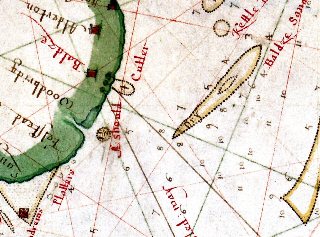
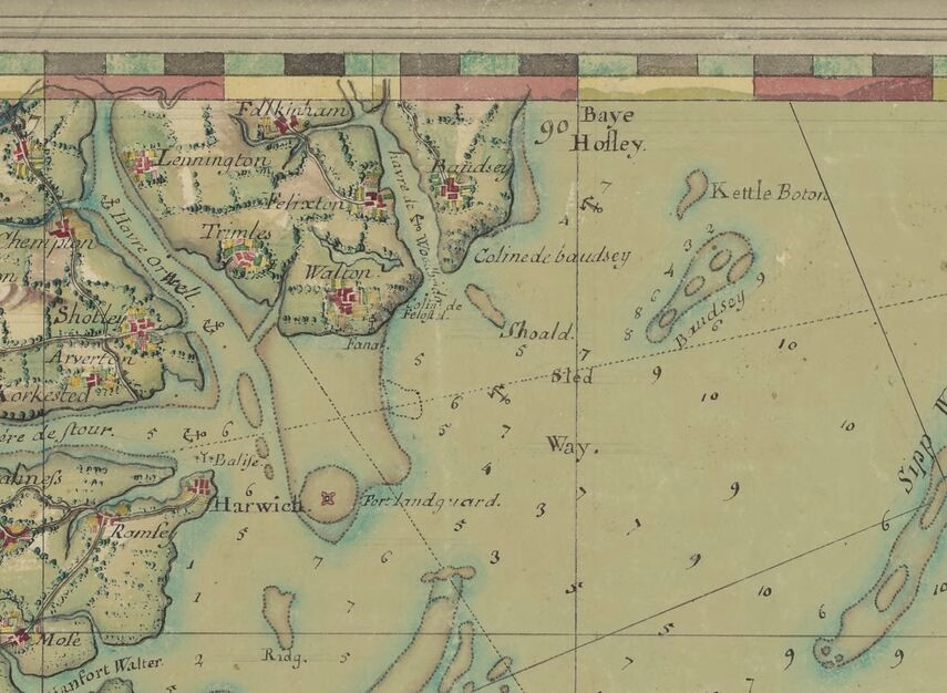
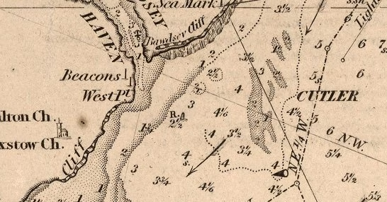
From the seventeenth century, the 1682 Thornton chart, above, shows Redbeard near the mouth of the Deben and Cutler as a shoal attached to the cliff near Bawdsey Church: the similarity to the depiction of Landguard suggests a shingle outcrop6Note also the features South of Orford Ness.. The 1738 Seller chart appears to be a close copy, the 1756 Mount71756 A Correct Chart of the Sea Coasts of England, Flanders and Holland, W. and J. Mount and T. Page.
chart also. None show a bank between the shore and Bawdsey Sand.
The first clear mention of ‘Cutler 6 Foote’ is on the 1683 Greenvile Collins chart and pilot in an offshore position with Redbeard not mentioned although two shoal promontories are depicted corresponding to the charts above. Cutler is also shown clearly in 1782 by Chandler, although in a different position with no Redbeard, this chart has signs of borrowing from the Collins chart.
A different view is shown on the 1760 Carte de Cotes Meridionales d’Angleterre with a single shoal perpendicular to the coastline. This is perhaps more a work of art than a useful chart so discounted.
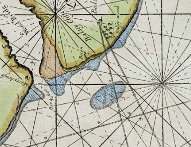
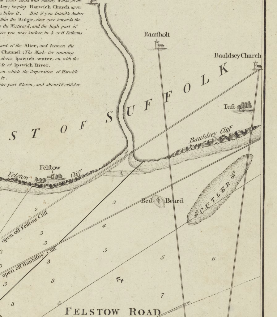
The 1794 Burn chart shows Redbeard as a distinct feature about 900m offshore, with Cutler as a larger feature between 400m and 1700m offshore. The chart is not cartographically accurate in several respects8Cutler is too far south by Collin’s bearings, note the positions of Cutler and the Churches.. The 1786 Sayer & Bennett and 1800 Heather charts appear to have copied Burn. According to the Burn chart, the Red Beard feature is about 450mx250m and the Cutler feature is about 2300mx600m. Bearings are given as Orford Church and Castle open off Bawdsey Cliff (the cliff has receded), and Ramsholt Church bears N a half W9Note that the bearing given is Magnetic (Declination was about 23 West at that time. The two bearing lines on the right, Ramsholt and Bawdsey are, using variation from chart of 23W. Ramsholt Ch. N 1/2 W = 354.5M – 23=331.5T) and Bawdsey Ch. N 1/2 E =005.5M – 23 = 342.5T. The chart is contemporary to the more reliable 1804 Spence larger scale chart which should be preferred.
The 1782 Chandler chart has Cutler in the modern position, there is an unnamed bank at the Deben entrance that could be Redbeard.
Cutler and Redbeard are shown in an 1815 Atlas. This chart is similar to the near-contemporary Burn chart but with Cutler closer to the modern position.
The 1804 Spence chart does not mention Redbeard and shows two fathoms (4m) in the suspect area. This is the earliest large-scale chart found and can be considered reliable. It would suggest that the Burn chart can be discounted. The shoal from the 1845 survey is to the left and the suspect shoal is to the right.
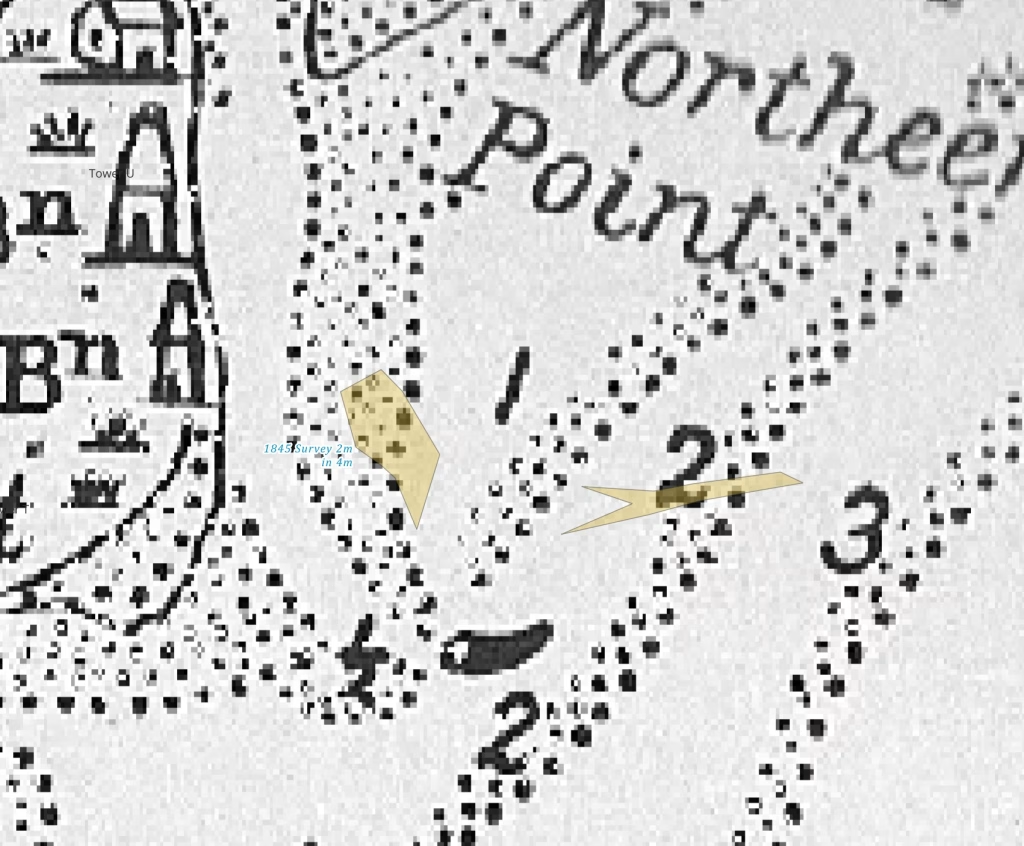
The detailed and reliable 1845 Deben Survey shows no less than 4m in the suspect area (centre), which suggests the feature is modern. This is the limit of the survey’s coverage, but there was a contemporary survey by HMS Porcupine that would cover Cutler. The Redbeard and Cutler shoals from the (dubious) Burn chart and the suspect area are overlaid on the survey below:
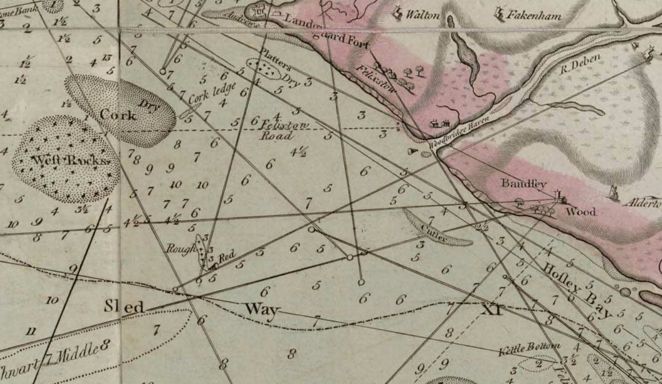
Inspection of the 1852 Imray Chart shows Cutler as a broken shoal at 2 fathoms (2m to 4m) in about (7.5m) to the west. This Chart conflated several shoals as Cutler in 7.5m in the area between modern Cutler and the shore.
Twentieth Century Charts
The 1945 Kreigsmarine Chart (probably based on WW1 Admiralty) shows a 4m shoal west of Cutler in an area of about 7.5m. The 1966 Admiralty Chart shows a similar shoal a little to the North. On the 2015 Chart, Cutler is shown to the east of the 1966 Chart which shows it to the east of the 1915 chart.

In the suspect area, an obstruction is shown in 2008 East Coast Rivers: the series of annual Deben chartlets which goes back to at least 2010 does not show the suspect area until 2013 (until then it had been covered by a sponsorship logo!) there are three patches of under 2m which by 2015 have coalesced into a single shoal similar to the Surfzone suspect, there is further shoaling until the 2024 edition. Given the rate of change since 2013 it seems likely that the feature is recent.
Where were Redbeard and Cutler?
Cutler
Cutler was not shown on the mid sixteenth-century Henry VIII chart but Redbeard was: is it possible that Cutler only appeared between then and the seventeenth century? This is most unlikely. When it did appear it was shown in two distinct positions, one onshore 168210 Thornton, the other offshore11Grenville Collins 1686, it is improbable that they were the same feature.
As the charts become more recent Cutler is shown more to the East and becomes more clearly defined. Much of this eastwards movement is likely to be the result of improved surveying rather than any migration: however, there has been a movement of material affecting both Redbeard and Cutler as described below:
…Cutler… has been recognised since the 1671 Seller chart, and prior to the late 1800s, showed little evidence of change. The record suggests that the feature broke down over the course of the late 1800s to a low in 1905, and subsequently built up again to within 30cm of its previous height by 1920. Since then, the bank has experienced a gradual lowering of about 1m. To the southwest of Cutler existed a small shoal called Red Beard which was present on most charts up until the early 1800s. It is clear that this feature was eroded away quite rapidly over the first few decades of the 19th century.
The name Cutler could have been applied to the inshore feature at first and later to the larger offshore feature.
Greenvile Collins can be considered reliable so Cutler has existed as an offshore feature12Also on the 1671 Seller Chart since at least the late seventeenth century and was probably there centuries before this.
Redbeard
The small-scale Burn chart should be ignored in favour of the contemporary Spence 1804 chart. The 1682 Thornton and 1782 Chandler charts both show a bank close to the entrance, this was probably the remnants of Redbeard.
Redbeard was a five-foot shoal in the mid-sixteenth century. Although it appeared on charts until the early nineteenth century, it had probably ceased to exist and been copied from earlier charts.
Between the Shore and Cutler
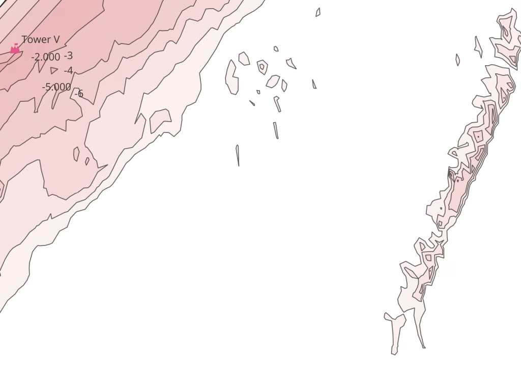
The charts from the mid-nineteenth to mid-twentieth century show an area of shoals between the shore and modern Cutler. These have been depicted in different ways in varying positions. Modern bathymetry shows no shoals down to 4m CD, the extract below shows no shoals shallower than the 5m contour.
The variation in Cutler’s charted position in modern times perhaps excuses some anomalies in earlier charts.
Different positions over the last century show the improvement in surveying, especially since the advent of GPS. No wonder shipwreck was so common.
It would be useful to check the early British Library maps and the, circa 1845, HMS Porcupine survey.
The New Unnamed Shoal
The suspect feature did not exist in 1804 or 1845 on charts that are large-scale and reliable, so must be modern. It appears on the 2019 Surfzone data but not on the 1984 Spot Depth bathymetry, although there is a small feature of 0.3m CD halfway along. The 2013 Spot Bathymetry agrees closely with the 2019 Surfzone data so the feature has developed since 1984.
Large-scale charts since 1845 would be worth checking (see UKHO Archive). It will be interesting to watch it evolve. Perhaps it deserves a name – Newbeard -or Longbeard? Perhaps Trinity House could be persuaded to scan the area when making the 2025 Deben and Ore Surveys? It may be possible to obtain detailed bathymetry from the TH Deben surveys.
Sources
Historical changes in the seabed of the greater Thames estuary
REDBEARD (lost). This sand lay off Bawdsey Cliff and may now form part of the Cutler. It is Redberde banke, c. 1540 Cott. Redberde, t. Hy. 8th Cott. Red Beard, 1787 Geo. Burns. No doubt to be associated with the Redberd family of Bawdsey (12th cent). – Arnott, William George. The Place Names of the Deben Valley Parishes.
From P.Wain: As a small (and probably irrelevant) aside on the naming of the Redberd bank rather than its formation:- there is a Thomas Redberd mentioned in the 1327 Lay Subsidy as being taxed at 13d. This would mean he may well have been quite prosperous
There is a Ralph Redberd mentioned as a ship’s master in 1338
There is a Robert Redberd also mentioned as a ship’s master in 1347
That is the final mention of Redberds as individuals but in the 1579 extent (survey) there is a piece of land called Redberde-gravecroft in Bawdsey. So the name lingered on
- surfzone_dem_2019-2019-2-TM33nw & surfzone_dem_2019-2019-2-TM33ne 2m resolution – only 2019
- bathymetry_coastal_multibeam-2018-0.5-TM33ne 0.5m resolution – 2018
- bathymetry_coastal_multibeam-2013-0.5-TM33nw & bathymetry_coastal_multibeam-2013-0.5-TM33ne -2013
Medin Portal Bathymetry – River Deben
Admiralty Seabed Mapping – 1984 HI193 HI194 Thames Estuary Areas 1 and 2 Sledway and Shipway
2004 2006-361471 Hollesley Bay Approaches to the River Ore-7748fd21-383e-4af0-9e5c-2f7837ca56f5 – Orford Haven only
2013 Hollesly Bay to Felixstowe Seabed Mapping
See The UKHO Archive [ARCHIVED CONTENT] mainly early catalogues inc 1849.
Cutler is about 3300m by 600m max.
Footnotes
- 1Talk at Waldringfield by Prof. Helene Burningham December 2024
- 22008 East Coast Rivers and the annual Deben chartlets.
- 32018 0.5m resolution of Cutler Sand.
- 4would be useful to check the 1584 A chart of the east coast of England – Richard Poulter, not sure if this is the same as 1585 Harwich to Yarmouth which shows the bank but is not readable on my copy – needs a BL visit
- 5See W.G.Arnott, W G. Suffolk Estuary : The Story of the River Deben. N. Adlard – p23
- 6Note also the features South of Orford Ness.
- 71756 A Correct Chart of the Sea Coasts of England, Flanders and Holland, W. and J. Mount and T. Page
- 8Cutler is too far south by Collin’s bearings, note the positions of Cutler and the Churches.
- 9Note that the bearing given is Magnetic (Declination was about 23 West at that time. The two bearing lines on the right, Ramsholt and Bawdsey are, using variation from chart of 23W. Ramsholt Ch. N 1/2 W = 354.5M – 23=331.5T) and Bawdsey Ch. N 1/2 E =005.5M – 23 = 342.5T
- 10Thornton
- 11Grenville Collins 1686
- 12Also on the 1671 Seller Chart