As part of a plan to survey sections of the marina for depth, it was necessary to establish the difference in tidal height between SYH and the tide gauge at Harwich (HHA).
The HHA gauge gives predicted and actual tide for every ten minutes on a 24-hour basis: the data can be read into a spreadsheet, note that the time is local and the data is not dated.
To measure the depth at SYH, the yacht Carina in G216 was left to log the depth from its sounder for 22 hours and the data were recorded in a file along with the GPS position. Note that the surface in the berth is soft mud, which may give a fuzzy return. There was no significant movement of the boat in that period. This also gave a check on how much variation there was in the position and it varied over no more than 0.2m
Each depth value was reduced by the HHA tide at the same time. As the intervals were different, this was interpolated between adjacent HHA values. From the stand of HW in the interpolated values, the time of both HWs was estimated. This was used to assign hours before and after HW time (decimal) to each value of Depth-HHA (effectively CD of the berth). As the data ran over almost two tides, all values were sorted into before/after HW order.
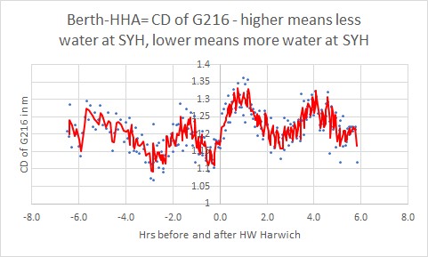
If a close approximation to the SYH-HHA difference could be made for, say each tide hour, then that could be used to correct the sounded depth. It would be expected that the tidal height at SYH would be lower on the flood and higher on the ebb and this is roughly what the chart below shows. However, when the variations were plotted over the tidal cycle the values were quite widely spread and had unexplained peaks. Until these data can be improved then only a rough correction can be made.
The CD of the berth varied from 1.07m to 1.36m with a median of 1.21m and a spread of 0.3m. If no adjustments were made then a spot depth could be in error by that amount due to this cause.

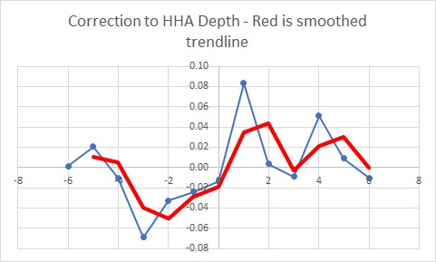
An attempt was made to construct a correction table but this was of limited value.

One option would be to take the HHA value and ignore the difference. This could result in an error of 0 to 0.3m plus any other errors. There could be an error of 0.05m in reading the depth sounder (can it read to better than 0.1m?), making a depth error of up to 0.35m before any other errors are included. Looking at the graph and assuming that the dip at HW+3 is bad data, then a reasonable guess would be that correction 0.3m could be deducted trom HHA on mid-flood and added mid-ebb with a smaller correction on either side, something like the table on the right.

When surveying, there is a problem in that the GPS antenna is about 6m from the sounder. and 1.5m from the centreline on the port side. This can be corrected by correcting the Lat/Lon by a vector of this distance along the Heading (strictly speaking COG but this will probably be too slow to react).
The next steps are:
- Calibrate the sounder on scrubbing posts.
- Collect survey data for an area – possibly the entrance?
- Construct a chart of adjusted soundings.
Calibrating the tide over 22 hours in a mud berth is not sufficient. Ideally, this needs to be done over a complete lunar cycle on a hard surface. A tide logger would be a good idea.
Test Chart – needs to have land contours removed and Lat/Lon coordinates added. Also, increase the size of Surfzone data to match the background. Make contour lines bolder?
Scrubbing Posts
Carina was put on the outside or north berth of the scrubbing posts. A tape measure was used to measure the depth on each side at 2.05m. The depth sound read 2.0m and the HHA tide gauge read 3.49m. So, the depth sounder over-reads by 0.05m and requires a correction of -0.05m to reach the actual depth.
The depth on the scrubbing posts is, therefore, 2.05-3.49=-1.44m or 1.44m above CD.
Notes
All files
The data used to date are in the spreadsheet.