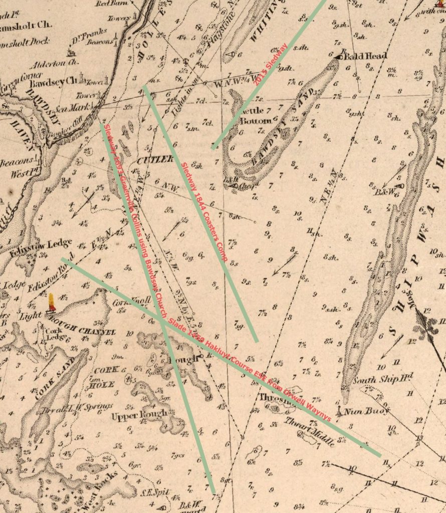
On the modern (2015) charts the Sledway is the channel between Cutler Sand to the West and Bawdsey Bank to the East. However, historically, the Sledway is the navigable sea bounded by the Cutler, Bawdsey Bank, Shipwash, Threshold, Roughs, Ridge and Cork, which affords access to the Havens. A sense of this is given in sailing directions from around 1450115C Hakluyt Local Sailing Directions :
“oute of Orwell waynys for to goo oute at the slade your cours is est southest, for cause of the rigge and the Eokkis, till ye com till xv. ffadome depe and for the long sande“
waynys = Fish Wiers, Eokkis=West Rocks, rigge=Ridge
The location of the Sledway varies over time: it can refer to the channel into Felixstowe Roads but it is also the channel from Hollesley Bay out to sea. In 1540 it was ‘ye slade’, 1686 ‘the Slead Way’, Sledway does not appear on the 1852 Chart but the sea mark is used to clear Roughs as well as the channel from Hollesley Bay anchorage to the Shipwash which agrees with the description in the 1869 North sea Pilot and is an improvement on Greenville Collins’ bearing.

The Sea-Mark
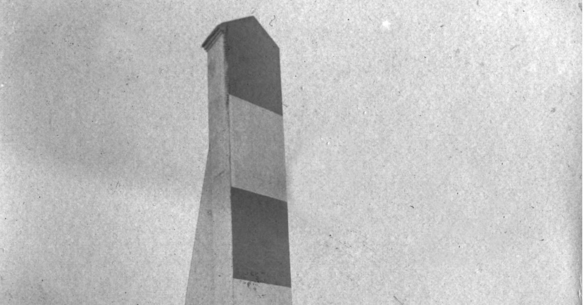
In the eighteenth and nineteenth centuries, the channel was of sufficient importance to have its own sea-mark on the Bawdsey Cliff.
Origin of the Name
The term ‘Slad’ or ‘Sled’, according to H.Muir Evans, is Anglo-Saxon and refers to a strip of greensward between two breadths of a plough or, a strip of marshy ground in a valley bottom2Muir Evans, Harold. “SANDS, GATS and SWATCHWAYS between HARWICH and the NORE.” Mariners Mirror, 1930. . If we think of the various shoals and the relative narrowness of the channel then this seems appropriate. Evans finds many terrestrial references among the names of sea features and the Sledway.
Notes
- 15C Hakluyt Local Sailing Directions “oute of Orwell waynys for to goo oute at the slade your cours is est southest, for cause of the rigge (Ridge)and the Eokkis,(West Rocks) till ye com till xv. ffadome depe and for the long sande” – If we take the Waynys as being the mid-point between Wadgate Ledge SHM and Felixstowe Ledge SHM this works. The other features are Ridge and Rocks(West). Usefully this indicates that the “waynys” were somewhere between the modern Wadgate Ledge and Felixstowe Ledge buoys. Waynys or wains refers to a form of sea-wall perhaps connected with fishing weirs.
- 1588 Lucas Waghenears Dutch Atlas East Coast shows what appear to be the leading beacons, or meets, but no sea mark.
- 1686 Greenvile Collins Chart shows ‘Beacon’ but uses the Church as a sea-mark. References Sledway: – The Buoy of the Gunfleet* beareth from the Naze south east by east easterly. You may stand into seven and eight Fathom along the side of the West-Rocks* into the Sledway, keeping Balsey Church north by west and north north west till you bring Harwich Steeple on the Brewhouse (that lyeth to the northward of Languard-Fort) which will carry you clear of the Cork-ledge, on which is two Fathom and a half at low-water, and then stand to the westward, and keep Orford Church and Castle open of Balsey-Cliff a Sails breadth, till you have the Lights together, keeping them so till you are past the Andrews, and then follow the former Directions for sailing into Harwich.
- 1752 John Mount’s Sailing Directions make no mention of a sea mark at Bawdsey but are otherwise comprehensive suggesting the mark was not used at that time.
- 1794 Geo. Burns Chart does not show sea-mark and marks the “Sled” on Bawdsey Church.
- Late 18C Chandler and Heather charts do not show sea-mark and are vague on Sledway.
- 1804 Graeme Spence chart shows a sea-mark.
- 1845 Deben survey shows a sea-mark for the Sledway.
- 1844 The improved coaster’s guide, and Marine board examination, for the east coast – The Sledway is bounded by the SW end of Bawdsey Sand, the Kettle Bottom, and the SW end of the Whiting, on one side; the Cutler, Cork Knot and Rough, on the other side. The marks used are Butley Church, Boyton Mill and Boyton Wood. There is no mention of the sea-mark.
- 1869 North Sea Pilot – “Bawdsey Cliff is of a dark red colour, and bears upon its face numerous marks of recent land-slips. A large white house among wood, inland and to the northward of the cliff, a windmill at Alderton, and Bawdsey church, with its broad stunted tower, are all plain objects. Bawdsey sea-mark, an obelisk painted red and white in horizontal bands, stands close to the brink of the cliff towards its north-east end; in line with Bawdsey church, it leads through the Sledway between Bawdsey bank and the Roughs…”
- 1903 Meesum East Coast Rivers shows an Obelisk.
- 1915 USNO England East Coast Pilot Harwich extract -Bawdsey Sea Mark, an obelisk painted red and white in horizontal bands, stands near the northeast end of the cliff.
- 2007 England’s Historic Seascapes description uses the modern description of Sledway.
Footnotes
- 1
- 2Muir Evans, Harold. “SANDS, GATS and SWATCHWAYS between HARWICH and the NORE.” Mariners Mirror, 1930.
- 1
- 2Muir Evans, Harold. “SANDS, GATS and SWATCHWAYS between HARWICH and the NORE.” Mariners Mirror, 1930.
Image Credits and Sources
- FI Bawdsey-Seamark-from-Di-Coulting-1447×2048@2x_cr: Courtesy of Coulting, Di - Boathouse Cafe Bawdsey | All Rights Reserved
